Tuesday, May 31, 2011

Bixler Saddle and Clover Spring

To celebrate our 22nd wedding anniversary Kathy, the girls and I spent three days adventuring in central Arizona. The first day, May 2o, 2011, was spent fishing at Lynx Lake and is a topic for another post. The second day we planned to drive up to Williams, AZ and hike the Bixler Saddle trail to the top of Bill William's mountain. This is a hike I have wanted to do for a long time but the need for a high clearance 4wd vehicle killed those ideas. But we now have this cool Jeep so I figured this was our chance.

Set off early and found the Devil Dog exit from I-40 easily and set off into the woods. FR 108 is nicely maintained but I knew FR 45 would be rough. A couple of days before there was a huge storm that dumped lots of rain and snow across northern and central Arizona. Turns out this would be an issue all day.

We quickly made a wrong turn and ended up taking the round about way to FR 45. We did find the road (I think) and it was in pretty rough shape. The jeep was doing great over the slick rocks and muddy ground. I, however, was getting nervous.

The scenery was amazing. In the picture below you can see Bixler mountain and the we were looking for the trail head to the left of the mountain.

The road got steeper and muddier the farther in we went. I finally got to the point where things did not 'feel' right and I decided to turn around before we got in over out heads.

My street tires where loading up with mud and I was starting to loose traction. The jeep does not look bad in the pictures. I was actually surprised that there was no mud on the body.

I am convinced that turning around was the right thing to do. We were alone and not sure we were actually on the right road. If we had gotten stuck it would have meant walking out for help. I am sure a more experienced driver would of had no trouble getting to the trail.

Once things dry out up there or I get some new tires, we will be back. Once we turned around we drove into Williams to try the Bill Williams Mountain Trail. This was lots easier to get to as the trail head is right next to the ranger station and the road is paved.

The trail is only three miles to the top of the mountain, but as you can see, there is 2200' of elevation gain. I knew this would be tough. We set off and things looked good at the beginning.

The trail soon got steep and rocky. To make matters worse there was lots of mud. I guess this should not have been a surprise.


Once we got to the Clover Spring trail head we decided that there was no way we would make it to the top of the mountain. We had traveled about a mile and it had taken an hour and we were nearly out of gas. The Clover Spring trail is an easier trail and it looked dry.


Once we got to the spring we stopped for a rest and a snack. The scenery was beautiful and the weather was perfect. Going back down was much easier but the muddy spots were a little trickier.


We were all very happy to be back in the Jeep at the end of the hike. It was a great day.

Tuesday, May 24, 2011

Castle Hot Springs Road

On May 14, 2011 we took another drive in the Jeep. This time we went exploring the Castle Hot Springs Road that runs through the desert and the mountains between Morristown and Lake Pleasant. It is a well maintained dirt road with only a few rough spots, mostly at the many stream crossings.


The road is named after the old Castle Hot Springs Resort that was very popular in the 1920's and 30's. The resort closed down after a fire in the 1970's. There is still quite a bit left and this is what we were out to see.

Along the way you pass through lots of open range land and we saw lots of cattle as well as this horse. Not sure what she was doing walking down the road but she looked to be in good shape.


After several dusty miles we got to the first area that we thought was Castle Hot Springs. There was some ruins and a wall. There was also lots of palm trees and an old barn. I am not sure if this area is part of the old resort but it was neat to see.


About a mile farther down the road we found the real resort location. There is a full-time caretaker and this part is well maintained. There is another old barn and the really nice old house. The grounds are still beautiful.


The road follows the river for about three miles after the resort. It is a little rough in that part but not bad. You pass several small mining outposts. Finally, you will see Lake Pleasant in the distance. It was a warm day and we were really looking forward to goofing around in the lake for a while.


We found a nice little cove and spent a couple of hours at the lake. It was another great day.

Thursday, May 05, 2011

First Ding

I knew it had to happen some time but I was hoping it would be after it turned three thousand miles, but I have my first ding on the Jeep. The other day I was driving home from a friend's house when I heard the loudest rock hit I have ever heard. It was so loud I thought that maybe it was something other than a glass hit. I could not see any issues from the inside of the Jeep and by the time I got home I had forgotten about it. The next day we hopped in the Jeep and Kathy saw a 6" crack in the wind shield. When I looked at the outside this is what I saw.


Whatever it was it even chipped the paint of the window frame.

Monday, April 25, 2011

Agua Caliente Road

This past Saturday (April 22) the family and I set out on another Jeep Adventure. This time we decided (OK I decided) to explore the area along the Agua Caliente Road southwest of Buckeye. This looked to be a really good road to checkout as it is dirt but well maintained. It also goes right past the 'ghost town' of Sundad, which I really wanted to check out.


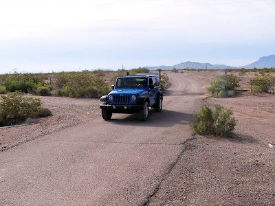
Most of the early part of the road is flat desert and you can see for miles in all directions. Palo Verde Nuclear Generating Station is visible to the north of the road. The road is very well maintained as I expected and is passable to just about any street car.


After about ten miles you come to a grade crossing of the Union Pacific Railroad. This is a pretty lonely spot. The tracks out this far west of Phoenix are only used for storage so you rarely see a train out here.
Below is looking east towards Palo Verde. The think the mountains that you can see faintly in the distance are the White Tanks.

Looking west you can see Yellow Medicine Hills just north of the tracks.


After another 25 or so miles of driving, and passing through some fun curvy stuff in the Gila Bend Mountains, you will see the turn-off for Sundad. The trail that leads to the site is on the east side of the Agua Caliente Rd and is marked by a white triangular rock garden. It is actually easy to see. You follow this trail (which can be a little rough and should be done by 4WD only) for about a mile to the town site. There is not much left of Sundad other than some interesting rock gardens and some building foundations.


After goofing around in Sundad for a while we continued on until we reached the Hyder Rd just outside Camel AZ. There is really not much out here but you will cross the railroad again. There was about 5 miles of railroad cars on the tracks. We followed Hyder Rd northeast until it connected with Rocky Point Rd. This is another dirt road that is a little rough as it goes across and old lava field. This road goes south around Oatman mountain and then crosses the Gila River. We followed this road until we reached the Painted Rock Historic Park. This is a nice little park with picnic tables and a large covered ramada. It also has restrooms. This was perfect place for lunch.

After lunch we walked the short trail around a large pile of boulders that were covered in hieroglyphics. Most of the drawings date back 7000 or more years ago and others only a few hundred years. Mixed in are names and dates of visitors going back to the early 1900s and late 1800s. This area used to be right next to the Butterfield stage route. There are lots of historic markers and information and it was a very interesting little park.


After leaving the park we followed Painted Rock Dam Rd, which is nicely paved, around south until it connects with Interstate 8 at exit 102. This part was interesting because is goes right past the site of the huge solar energy project.

Once on the interstate we went east to Gila Bend and the exited and got on State Road 238. I wanted to find a road across the Gila Indian Reservation that goes north along the east side of the Estrella Mountains. On my map this road is called Rio Bravo Rd and connects with AZ 238 west of Heaton. I was hoping this road would be as well maintained as Agua Caliente Rd but this was not to be.

We found the road and headed north but things just did not look right. There was lots of old buildings and junk right at the start of the road and it was clearly not well maintained. We pressed on and after a while we decided that we were, in fact, on the right road. Once you get to the base of the Estrella mts the road changes names (not marked on the road itself) to Santa Cruz Rd and should take you north to the town of Santa Cruz on the reservation. The road runs parallel to Voah Shun Rd and actually cross it a couple of times. This makes picking the route a little tricky. To make matters worse neither road is well maintained at all and we were soon in over our heads. For several miles of the drive the road was dead straight and nothing but deep loose sand. I have visions of being stuck in the sand in the middle of nowhere. It was a very stressful drive and a little hard on the Jeep.

Nothing broke and we did not get stuck. We finally made it to Santa Cruz and found only this little church. From here the roads were all paved all the way back home.


In all we drove about 200 miles and saw some really beautiful parts of the state. We had a great adventure and I think we are ready for more!